We didn’t know much about Capitol Reef National Park when we arrived there on Tuesday. Capitol Reef is best known for its Waterpocket Fold, step-like cliffs which run the length of the park. A reef refers to a barrier which inhibits travelers, hence the park’s name.
Days 87 – 89
October 28 – October 30, 2014
Miles 9862 – 10258

The closest town is Torrey, UT where we got a hotel. We found the town to still be mostly open, however some places were starting to shut down for the winter. Had we arrived in November, I think the town would have been more scarcely populated than we found it in late October. Before the sunset, we decided to take a quick drive into the park and get a look around.
The Waterpocket Fold is obvious from a distance outside of the park. When you get closer, rock formations in the fold are named and identified. First we came across The Chimney. We continued down the road a bite further, but turned back when it got dark. Dinner that night was sandwiches from a Subway next to the hotel.

The next morning we took our time exploring Capitol Reef and mostly followed the route suggested in our guidebook. We stopped first at Gooseneck Overlook and the visitors center where we asked about slot canyons in the park.

Our big hikes of the day were a 2.0 mile (4.0 mile round trip) out and back on Grand Wash and a 1.0 mile (2.0 mile round trip) in Capitol Gorge. The hike along Grand Wash was a nice, easy hike through steep canyon walls. I think Grand Wash would be a good substitution hike for someone unable to hike ‘the Narrows’ in Zion due to its difficulty. A wash is the path that water takes when it rains as it is the lowest point and in some cases the water has carved out enormous canyons.


The Capital Gorge hike was also similar, a walk on a relativity flat and sandy wash, but along the way are petroglyphs, the pioneer register, and potholes of water known as the tanks. We had only planned to walk a half mile to the pioneer register, but there was no sign so we walked past and it found ourselves at the spur for the tanks before we knew it. Since we had gone that far already, we decided to hike the steep 0.2 mile cliff up to the tanks. On the way back we walked slower and found the pioneer register which is basically graffiti left by pioneers saying their names and the year they were there. (There was however a sign under modern graffiti saying it was illegal which seemed to get more attention, at least by us, than the unmarked registry).


On our way back through the park, we stopped at the Gilford House in Fruita for pie. Fruita is the remains of a pioneer settlement in the park. The settlers planted acres of fruit orchards, hence the name, and visitors to the park can pick the fruit when it is in season. The pie from the Gifford House was recommended to us by a fellow traveler we met in Zion. We had strawberry rhubarb and devoured every bite of it.

Before leaving the park, we headed east to the Petroglyphs Overlook where you can see Native American drawings of animals and people. We drove further east to see more of the park, but didn’t stop at any sites. For dinner we ate at the Red Rim Patio where we both had spaghetti. A meal with spaghetti, two meat balls, salad, and garlic bread was only $8, but you do get what you pay for.

For our last day in Capitol Reef, we went hiking in a slot canyon. The visitors center had recommended three slot canyons to us; Burro Wash, Cottonwood Wash, and Sheets Gulch. We talked to the visitors center about each and did a little research online before deciding on Burro Wash. There was some chance that swimming may be involved in the others, and in late October that didn’t seem like a good idea. The first 2.0 miles of the hike are just along a wash through the desert to get to the Canyon. Burro Wash is definitely not for the claustrophobic. For long lengths of the canyon we shimmied and squeezed between two tight walls.

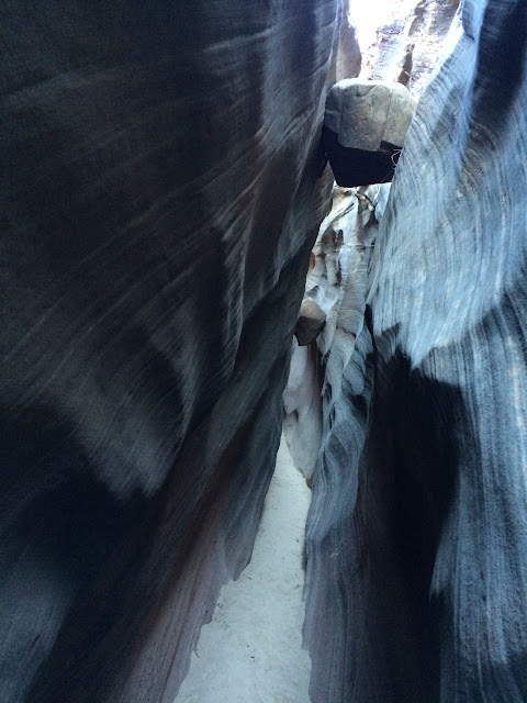

There wasn’t too much scrambling involved, just a few choke stones that we climbed over. Choke stones are big rocks that got washed down the canyon and got stuck, blocking the path. The trail description indicated that after 3 miles, we would encounter an impassible choke stone, and the way around would be to backtrack and friction climb up the steep slick rock on the side of the trail and drop back in above. Sure enough, we encountered this large choke stone and it was preceded by a large pool of water. After attempting multiple times (along with another hiker) to go up the slick rock and failing to find a safe path around, we decided to turn back. If we would have found the path, the trail would have ended after another mile at another choke stone impassible to most. We finished our hike mid-afternoon and left Capitol Reef for our next destinations.
More Photographs


Pingback: Our Top 10 American Hikes | Herr We Go